
This website uses cookies to improve your experience. We\'ll assume you\'re ok with this, but you can opt-out if you wish. Read More
In case of sale of your personal information, you may opt out by using the link Do Not Sell My Personal Information
If you’ve already done the West Highland Way, you might be on the lookout for a new challenge.
Scotland is criss-crossed with public rights of way and is blessed with world-beating access legislation. It can make the choice of what to do next more complicated. We’ve picked out some alternatives for you here. Some of the options we’ve listed below may require you to have a wee bit more familiarity with navigational skills, than you might have needed on the West Highland Way.
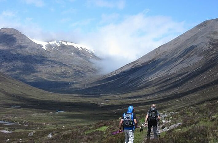
is a high mountain pass through the center of the Cairngorms National Park. It is a minimum of 19 miles and you can walk it over 1 or 2 days. The main difficulty with the Lairig Ghru is not the length of the walk but the logistics. You can start the walk from either end, close to Braemar or close to Aviemore. However, there are no roads which run through the middle of the Cairngorms National Park. To return to your starting point, you will need to travel for hours by public transport via Aberdeen or Perth.
Alternatively, you could book our Lairig Ghru Logistics package and we will take care of everything except the walking for you. All you need to do is to book your transport to and from Aviemore. We will pick you up from Aviemore (if you’re travelling up by train), transfer you to Fraoch Lodge, feed you, give you a comfy bed and take you round to the start of the walk, then we’ll stay in touch with you so we can be at the end of the walk to meet you. We’ll take you back to Fraoch Lodge, feed you again.
If you would like to take a guide for the Lairig Ghru trip we can also organise this for you.
Self-guided Lairig Ghru logistics
The Great Glen Way is almost an extension of the West Highland Way. It runs from Fort William to Inverness. It is 79 miles long and for those of you who don’t know, the Great Glen is home to both the Caledonian Canal and Loch Ness.
There’s a high route alternative which gives a bird’s eye view down on to Loch Ness, but is probably too far away to spot Nessie without very powerful binoculars.
Top Tip: Stop in at the Loch Ness Clayworks tea room. Watch out for midgies if you sit outside on a still day. It’s a lovely peaceful spot above Drumnadochit and if you have a wee space in your pack, the pottery Rebecca produces is lovely. (We have several examples here at Fraoch Lodge.)
It is relatively easy to arrange to walk the Great Glen Way on your own. However, if you prefer the security of knowing that everything is arranged, you can always contact a company like MacsAdventures. MacsAdventures specialise in arranging self-guided long-distance walks for their customers
If you would like to cycle the Great Glen way, we would recommend speaking to “Ticket To Ride” who are based in Inverness. Ticket to Ride can either provide a specialised bike taxi service if you have your own bike, or they can arrange bike hire/a self-guided biking adventure for the whole route.
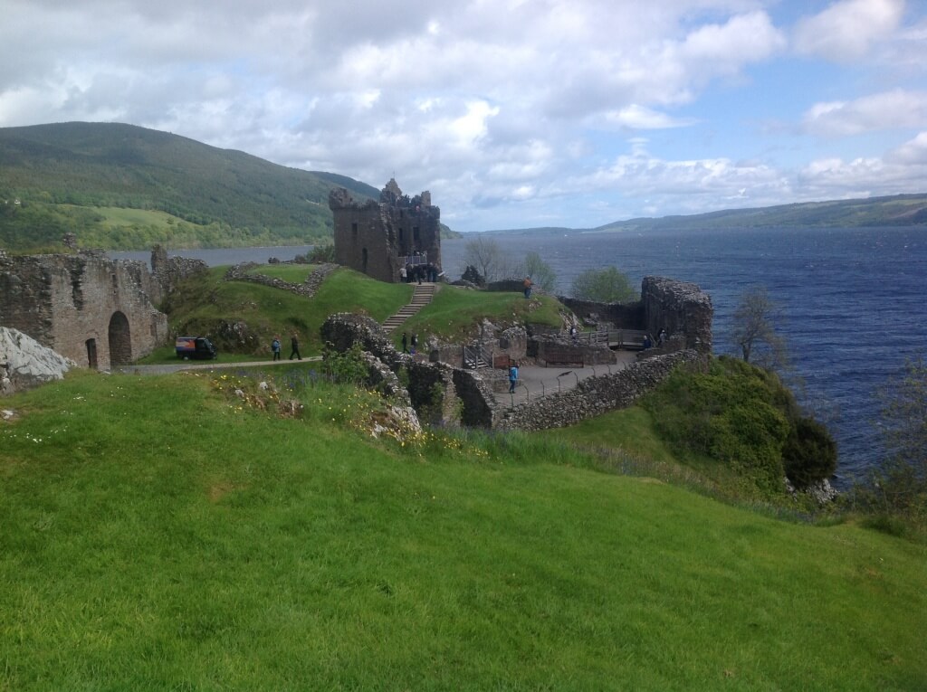
Visit Loch Ness
Moray Coast route.
The Moray coastal route is only about 50 miles long and is equally accessible to cyclists.
This route has marvellous landscapes from rugged cliffs, caves and sheltered coves to fishertown harbours and sweeping stretches of sandy beaches. Moray has a coastline alive with wildlife that would be the envy of many other regions in Britain. Many visitors are drawn by the resident bottlenose dolphin population or by the abundant bird life found along the rugged cliffs.
The Moray Coast has great variety in scenery, and you will always be rewarded with great views out over the Moray Firth. The coastline has great wilderness quality with imposing cliffs and rare plants, but is never far from civilisation. The path links a number of attractive coastal villages and towns, with quaint harbours and extensive services and accommodation.
The route abounds with history. You can see the fishing heritage of the coastal settlements at a number of local museums and the ice houses of Tugnet and Findhorn. Burghead has the remains of a Pictish fort and harbour warehouses designed by Thomas Telford.
TIP: Some of the route is on hard surfaces, particularly in and around the villages, which can be hard on the feet. Personally I would recommend this route as a bike ride. Scot Mountain Holidays can help with the logistics if you have a minimum of 2 people interested in walking or cycling this route.
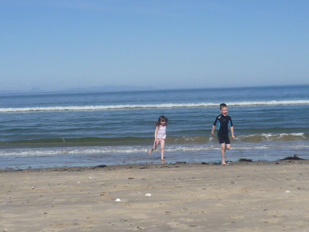
Playing on the beach at Findhorn
This route is on my hit list to do on our mountain bikes. If you choose to do this route, you’ll find it much quieter than the other side of Loch Ness. For this route you’ll need a slightly higher level of fitness as the path is more undulating.
Main advantage: you’ll well away from the main A82 and the crowds who visit Drumnadrochit.
If the weather is in your favour, you’ll have amazing views not only of Loch Ness, but also of the mountains behind. Take a look at the Walkhighlands page for the route. The pictures there are inspiring. Can’t wait to follow this route in the Spring. Only issue – as with all long distance path is co-ordinating the pick up and drop off at the ends of the route, but the public city buses run from Inverness to Dores (one of our favourite spots on the south side of the loch.
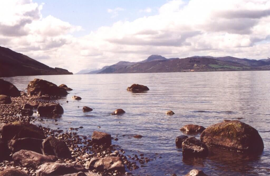
Loch Ness from the shore at Dores
This is the long distance path for whisky lovers. I forget how many distilleries you’ll pass but really you can hardly walk any of the sections without passing a distillery. Unfortunately some of them are not open to visitors, like Knockando, but if you’re prepared to make some small detours you can visit distilleries like Cardhu.
The Way is not exclusively about distilleries though. You’ll also pass through some classic Caledonian Pine Forests on the sections between Aviemore and Grantown on Spey with plenty of opportunities to forage for wild berries (raspberries and bilberries) and mushrooms (particularly chanterelles in the summer).
NB Carrbridge is currently undergoing consultation to install a path which will connect the village to the Speyside Way. Watch this space for more details.
There area already several options to extend the Speyside Way or even to turn it into a loop. You can connect with the Moray Coastal Path, the Dava Way, the Tomintoul Spur, and the Badenoch Way. Quite a diverse option which plenty of opportunities to customise your walk. You can even add in little diversions like a visit to Knockando Wool Mill (a favourite spot of ours) or the Cooperage (where they make the whisky barrels) or Ballindalloch Castle.
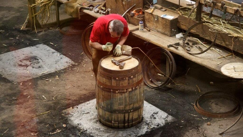
A cooper hard at work repairing casks at the Speyside Cooperage
The Copper Dog (at the Craigellachie Hotel), the Mashed Tun (in Aberlour), Knockando Wool Mill (for a light lunch or cake stop), the High Street Merchant (in Grantown on Spey), Nethy House – cafe with rooms (Nethybridge), the 1896 Gallery in Boat of Garten and the Old Bridge Inn in Aviemore.
A completely customisable, tailor-made adventure which starts with one day of guided exploration or navigation training in the Cairngorms. From here you can take your adventure where you please – more guided days, tours or supported exploring under your own guidance. Call us to discuss or for a quote. Check out some of the other experiences which guests have opted for from their bucket lists.
For guided adventures check out our full programme
There are several factors to consider when choosing an ice axe.
There are 2 reasons why you might need to buy an ice axe:
Your reason will define the type of axe you are looking for
How do you know if the axe you are looking at is designed for walking or climbing? Traditionally, one of the defining features is the length of the shaft.
The traditional method of choosing a walking ice axe
The traditional mantra: hold the axe by the head with the shaft pointing downwards. The point should be about 2 inches (5cm) from the ground.
Andy’s tip: I never really warmed to this line of thinking. After many years experience as a winter skills instructor, it quickly became apparent to me that this method was outdated.
A walking axe is very much a multi purpose tool with the user asking it to perform a whole number of tasks in a single outing. Some tasks may well be better served by having a longer shaft whilst others are not. It is therefore going to boil down to a bit of a compromise but I would suggest the shaft length for a walking axe should be no longer than 55 cm.
Techniques where a shaft length of over 55 cm is advantageous:
Techniques where a shaft length of 55 cm and under is advantageous:
I’ve found an axe with a long shaft is often ungainly to swing
Andrew Bateman
When you’re thinking about visiting the Pyrenees or the Alps or even the Andes, it would be a good idea before you go to give yourself a bit of a safety head start by learning basic safe movement in winter conditions – try a 2 day winter skills trip.
If you’re going on a guided trip a 2 Day winter skills course should give you enough skills to be safe with your instructor who will take care of the navigation and group management for you.
However you’d like to be more independent in the hills you may want to consider the full 5 day Winter Skills and Navigation course. You’ll learn how to deal with “whiteout” conditions as well as technical safety skills so that you can remain calm no matter what nature throws at you.
For more tips please check out our: Top 10 tips for winter skills or consider why you should want to book a winter skills course
For further guided walking holiday options try our main home page
![]() Scot Mountain Holidays (Ltd),
Fraoch Lodge, Deshar Road,
Boat of Garten,
PH24 3BN
Scot Mountain Holidays (Ltd),
Fraoch Lodge, Deshar Road,
Boat of Garten,
PH24 3BN


All content © Copyright Scot Mountain Holidays 2026
Responsive web design by Summit Web Solutions