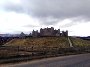
Even today, many walks in the Highlands of Scotland have a historical focus. Ruthven barracks stands abandoned on a hill surrounded by the nature reserve of Insh Marshes. It serves as a monument to the last major civil uprising and pitched battle on British soil. It witnessed both Jacobite success and Jacobite failure. This is where the last remnants of the Jacobite forces regrouped after the battle of Culloden, preparing the make a last stand – only to hear that they had been deserted by their commander in chief – Bonnie Prince Charlie.
 Ruthven Barracks – a redcoat stronghold in the heart of Jacobite country, destroyed by Jacobites in 1746
The barracks were built after the 1715 rising to control the Highlanders but were attacked and taken by the Jacobite rebels led by Bonnie Prince Charlie in 1745. The site itself has a much longer history than this but there is not much evidence now of it’s previous history.
Park in the parking area for Ruthven Barracks. At the top of the car park there is a farm gate which you need to go through to access the track. Follow the track up and bear right behind a stone wall, following the grassy track upwards.
Continue ahead as the track heads upwards and passes between 2 small hills. When you see the track heading towards the right to a ruined house, continue straight ahead passing a tree on the right. At this point you’ll need to go through a wooden farm gate before heading onto the open moorland ahead. Follow a wee path, much less distinct than the previous track. The path will continue across grassy and heathery ground to a more distinct tract rising diagonally across the wee hill opposite. The ground here can sometimes be wet.
Cross a small stream here on the stepping stones and join a wider path heading up the hill and slightly to the right. The path climbs gently but doesn’t quite reach the summit of Beinn Bhuidhe (yellow mountain). You’ll get a good view of Kingussie behind you from this point.
For a relatively short distance here the path is very boggy and waterlogged. If you manage to bypass it without getting wet feet, you’ll be doing very well. The boggy ground seems to cover the whole area. You’ll also probably need to keep to the heather at the side of the path in places in order to keep your fft dry. After a while the path will more indistinct but is marked by a series of stone cairns. At this point you’ll pretty much be at the high point and will have views down the other side of the hill you’ve been climbing.
Just before you go into the Woods of Glentromie, you’ll have to climb a high stile over a deer fence.
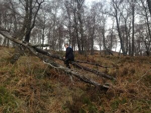
Cross this stile and follow the path into the woodland, which makes a nice change from the moor and heather you’ve been walking through up until this point. The path weaves downhill and can be wet at times. You’ll also need to bypass a couple of fallen trees at points.
 One method of crossing the fallen trees – they are much easier to cross but if you’re 8 you have to climb!
Eventually the path reaches a smaller stile and then goes left and crosses a larger stile to emerge onto a road. Turn left and follow the road past a house and over the River Tromie.
After the bridge turn left and follow the road down Glen Tromie eventually reaching the B970 at Tromie Bridge.
Turn left at the road and cross the bridge. Immediately turn right through a wooden gate into the RSPB reserve Tromie Bridge Meadow. This makes up part of the long distance route, the Badenoch Way. This section of the route follows markers with white circles. The route follows a grassy track through woods and then around the edge of the meadow next to the River Tromie.
Tromie Mills, a very well-kept distillery is visible on the other side of the river, but you never really get a good enough view from the path for a particularly good photo. Climb up a gentle bank and pass through a kissing gate marked nature trail. Follow the path next to a wall and then turn left uphill following the white markers.
You’ll cross some sparse birch woods with heather underfoot on a clear path along a small ridge. It’s a delightful section of the route. Keep following the white circular markers and pass through another kissing gate.
Turn right at a small marker post and then cross a vehicular track and go through a small gate. Continue on the path and pass through another gate and you soon reach a sign where you can make a diversion to a good viewpoint and picnic area.
To continue on the trail turn left at this sign and follow the path as it contours along the edge of the higher ground above the Insh Marshes. It passes through a gate and over a footbridge just after the diversion down to Invertromie Hide. Just before the carpark there is an information centre about the birdlife on the reserve. Continue down to the parking area and turn left and left again to emerge onto the B970.
If you are following this route as part of our self-guided itinerary (it is not currently one of the selected routes but is an optional extra), we will arrange to pick you up at this car park at the designated finish time and return you to Fraoch Lodge for tea and cake before relaxing and enjoying a lovely evening meal with us.
If you are walking this route independently you will still have a hike of 1km along the road back to the Ruthven Barracks car park.
http://www.castlesfortsbattles.co.uk/highland/ruthven_barracks.html
http://www.undiscoveredscotland.co.uk/kingussie/ruthvenbarracks/
https://www.historicenvironment.scot/visit-a-place/places/ruthven-barracks/
http://www.bbc.co.uk/history/scottishhistory/union/trails_union_ruthven.shtml

Fraoch Lodge
We want to send a big thank you to everyone who participated in our latest contest and helped make it a success! In the end, we had over 300 entrants which was a fantastic result. We also received valuable feedback from the entrants which will be put to good use.
And a special congratulations to Diane Smith, the winner of our Gentle Giants Giveaway Contest. Congrats also go out to Claire Waugh and Clint Dillon for winning the runner up poster prize of the impressive panoramic view of the Cairngorms National Park.
The Gentle Giants Trip is a great opportunity for Diane Smith and their ‘plus one’ to bag a couple of Munro’s on their guided walking weekend with our very own Andy Bateman. Andy will safely lead the way, sharing his years of in depth knowledge of the area and its natural terrain. On this particular trip, the Munro’s ascended will be Ben Macdui and Cairn Gorm in Cairngorms National Park. Did you know that a mountain has to be at least 3000ft in order to qualify as a Munro? And did you know that Ben Macdui is the second highest mountain in the British Isles after Ben Nevis in Fort William?
Not only will Diane have a full weekend of walking, but they will take in some spectacular views on the way, such as Loch A’an as they ascend Ben Macdui…
Diane will have a delightful view of The Lairig Ghru (with the local pronunciation “Laarig Groo”). It is a spectacular mountain pass through the Cairngorms of Scotland. Historically used as a route between Deeside and Strathspey, in particular, a drove road for taking livestock on foot from one place to another.
And it doesn’t stop there. After an active day out on the hill, Diane and company get to put their feet up at Fraoch Lodge and enjoy a cuppa and cake o’clock which always goes down a treat. Tidying them over until it’s time for a delicious and hearty home cooked supper to set them up for the following days adventure.
All in all, the competition was such a success that we’ll be holding them more frequently. You’ll have a chance to enter to win our next giveaway coming soon 🙂 We look forward to welcoming …….. to the Scottish Highlands to enjoy their prize.
All content © Copyright Scot Mountain Holidays 2025
Responsive web design by Summit Web Solutions